
Introduction
Khojaly is a district located in the mountainous Karabakh region of Azerbaijan. Its territory was a part of the former Nagorno-Karabakh Autonomous Oblast (NKAO), established within the Azerbaijan Soviet Socialist Republic (SSR) and existed until 26 November 1991. NKAO was an administrative division established artificially in response to the territorial claims of the Armenian SSR. As a result of the Armenian claims on the territory, its administrative borders were purposefully defined in such a way as to ensure that the Armenian population constituted a majority. Khojaly was one of the few settlements of this administrative unit that was inhabited predominantly by Azerbaijanis.
In the early 1990s, an armed conflict engulfed the region when Armenia launched aggressive military action against Azerbaijan with the aim of implementing its long-standing plan towards occupying Azerbaijani territories. The unilateral secession of Nagorno-Karabakh from Azerbaijan and the annexation of it to Armenia constituted the core of this plan. As a result, Armenia occupied this region, including Khojaly and seven other districts of Azerbaijan. The war that followed this aggression took thirty thousand lives, and nearly one million Azerbaijanis became refugees and internally displaced persons, while thousands of people disappeared without a trace. Despite that more than twenty years, which have elapsed so far, there is no sign that Armenia will renounce its ongoing aggression and withdraw its troops from the occupied territories.
Geography
Khojaly has a total area of 940 square kilometres and a population before the conflict of 7,000. Khojaly is situated 10 kilometres to the northeast of Khankendi, on the crossroads of the Aghdam-Shusha and Askeran-Khankendi main roads. Having the only civil airport in the area, Khojaly was an important centre of communications and had become a refuge for Meskheti / Ahiska Turks fleeing bloody inter-ethnic clashes in Central Asia, as well as for Azerbaijani refugees driven out of Armenia.
The territory of the district is mainly mountainous. The highest peaks are Gizgala (2843m) and Girhgiz (2830m). With the exception of the high mountainous areas, it has a mild/warm climate. The high mountainous areas are covered with subalpine and alpine meadows. The main rivers are the Badara and Gargar. The topsoil is mainly comprised of uphill and mountain soils. 40% of the territory is rich with hazel, beech, maple, birch and other trees.
History and culture
Khojaly is a historical and cultural part of Azerbaijan. It belongs to the Khojaly-Gadabay culture dating back to the 14th-7th centuries B.C. Late Bronze Age and Early Iron Age funeral memorials, such as stone boxes; barrows and necropolis were discovered in this town. Khojaly also hosts historic architectural memorials – a round crypt (1356-1357) and a mausoleum (14th century). Also, various stone, bronze and bone adornments, as well as ceramic household items were found by archaeological excavations. The name of the Assyrian king Adad-narari (807-788 B.C.) was engraved on one of the beads found in Khojaly.
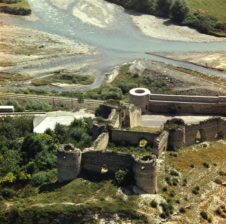
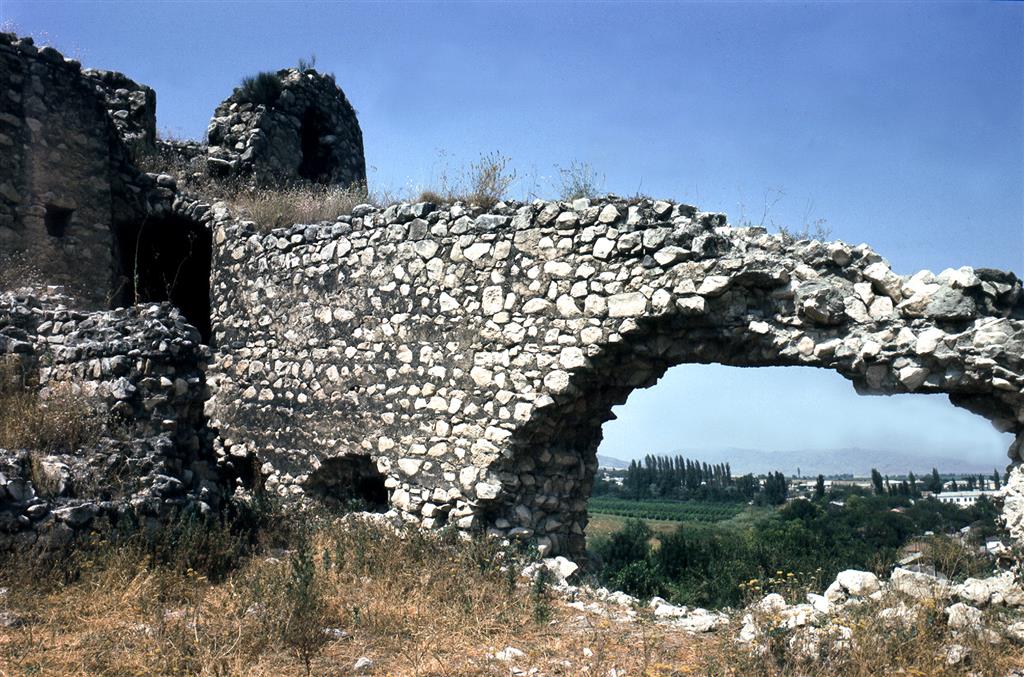
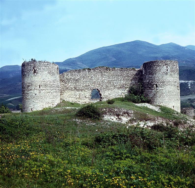
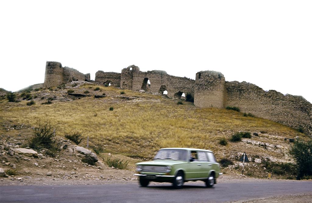
Erected in the 18th century by Karabakh khante Panah khan, Askeran castle is located within the administrative confines of Khojaly district, on both banks of the Gargar River. The castle, which was built from cobblestones, is composed of two fortifications. A significant milestone relating to this castle is that in 1810 the castle hosted peace talks between Russia and Iran, which further raised its historical significance.
Winegrowing, beekeeping, cattle and grain farming were the main activities of the Khojaly population. Prior to the Armenian occupation, tens of cultural institutions, museums, colleges, secondary schools, healthcare facilities, agricultural and industrial enterprises and other public organizations functioned in the district. There was a textile factory, two secondary schools and two junior high schools in the administrative centre of Khojaly.
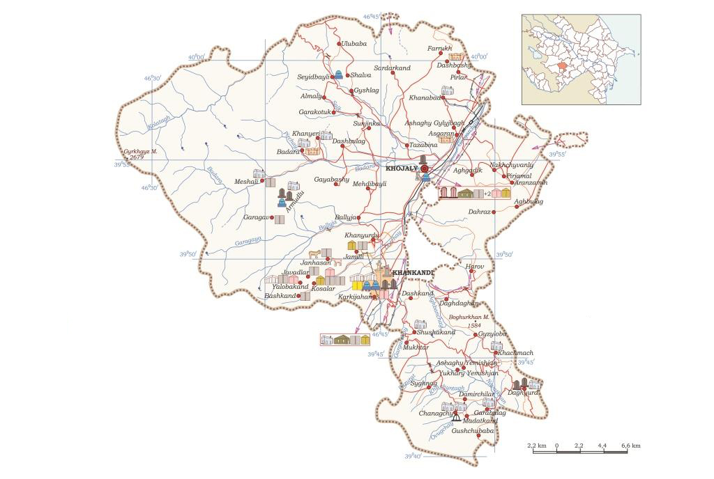
Administrative divisions
Neighbouring districts: Lachyn, Kalbajar, Aghdam, Khojavand and Shusha.
Khojaly has one city center, one settlement (Askeran) and 50 villages.
Villages: Almaly, Garakotuk, Ballyja, Khanyurdu, Mehdibayli, Jamilli, Chanagchy, Syghnag, Daghyurd, Dashbulag, Badara, Khanyeri, Gayabashy, Sunjinka, Harov, Daghdaghan, Khanabad, Aghgadik, Ashaghi Gylyjbagh, Kosalar, Bashkand, Janhasan, Tazabina, Gyshlag, Javadlar, Yalobakand, Garabulag, Damirchilar, Gushchubaba, Madatkand, Gyzyloba, Ashaghy Yemishjan, Khachmach, Yukhari Yemishjan, Meshali, Nakhchivanly, Aghbulag, Aranzamin, Dahraz, Pirjamal, Pirlar, Dashbashy, Farrukh, Seyidbayli, Ulubaba, Shushakand, Dashkand, Mukhtar, Sardarkand, Shalva.